Something that often puzzles visitors to German-speaking cities is that they appear to have two different metro systems, called the U-Bahn and the S-Bahn.


Having two different metro systems does seem slightly odd: at first glance, the only difference appears to be that the trains are different shapes and painted different colours.
But in fact, the differences between the U-Bahn and the S-Bahn are more than just cosmetic.
The two rapid transit systems accomplish something I call layering. The U-Bahn and the S-Bahn each serve a different market: the U-Bahn serves the immediate suburbs in the city’s urban area, while the S-Bahn goes out much further to the towns surrounding the city, in what is known as its city region.
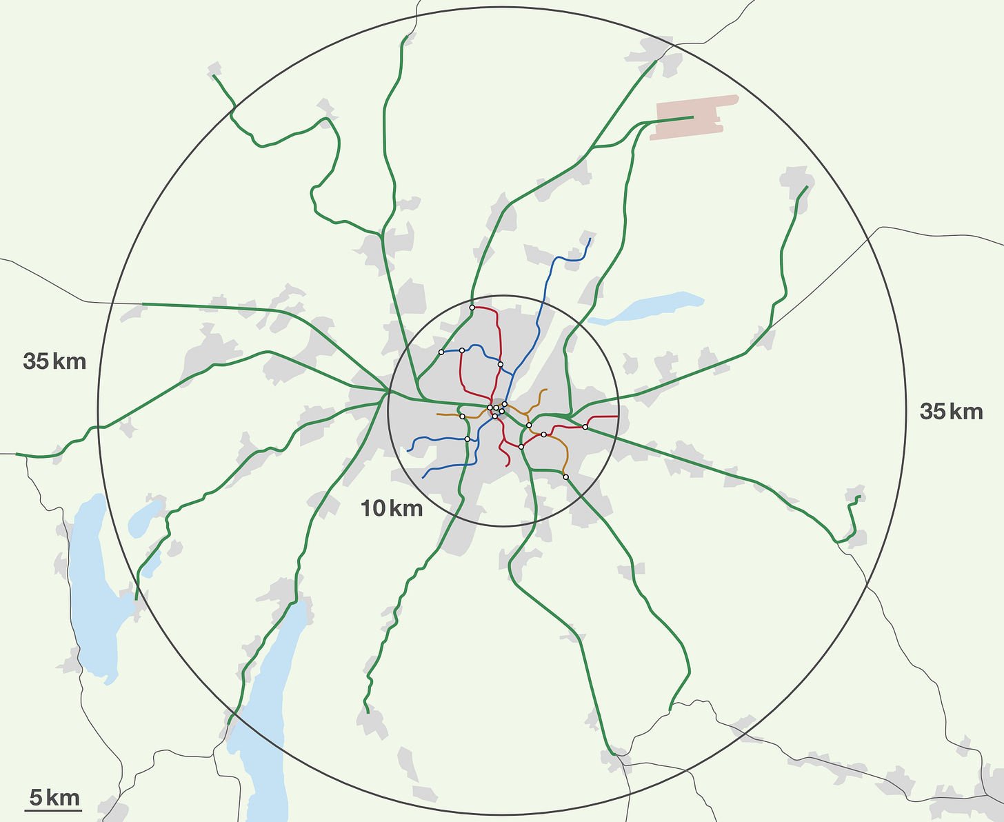
In Munich, for instance, the U-Bahn rarely strays further than 10 km from the city centre, while the S-Bahn mostly serves places within a 35–40 km radius.
The reason for this arrangement is simple: the city region demands a slightly different kind of rapid transit from the urban area: trains to the city region need to stop less often and travel faster, because the distances travelled are longer.
At the same time, both systems are integrated into a single public transport network: transfers between them are straightforward, and they use the same fare system.
This principle of ‘one network, two systems’ therefore enables places like Munich to get the best of both worlds: comprehensive service to both the city and its city region, while avoiding the inconvenience of having two entirely separate networks.
What is a city region?
A city region is the network of towns and smaller cities that surround a bigger city. The most obvious example is the ‘Wider South East’, the region roughly bounded by an arc stretching Brighton – Basingstoke – Oxford – Milton Keynes – Bedford – Cambridge – Colchester, and centred on London. This area, within a radius of roughly 85 km from the centre of London, has population of about 20,200,000. (By contrast, a radius of 85 km from central Paris has only 13,600,000 people.)
All of the towns and cities within this city region share an obvious characteristic: their economies are enmeshed with London’s.
Most obviously, people commute from places like Guildford and Brighton into London. Conversely, businesses (especially land-intensive ones) choose to situate themselves in Slough and Reading because they have easy access to London and London’s labour market, without having to pay London land prices.
London’s city region is unusual for having so many big settlements. This is thanks to postwar planning policy: the green belt checked the physical expansion of London, with the result that development ‘leapfrogged’ over the green belt to towns like Reading.
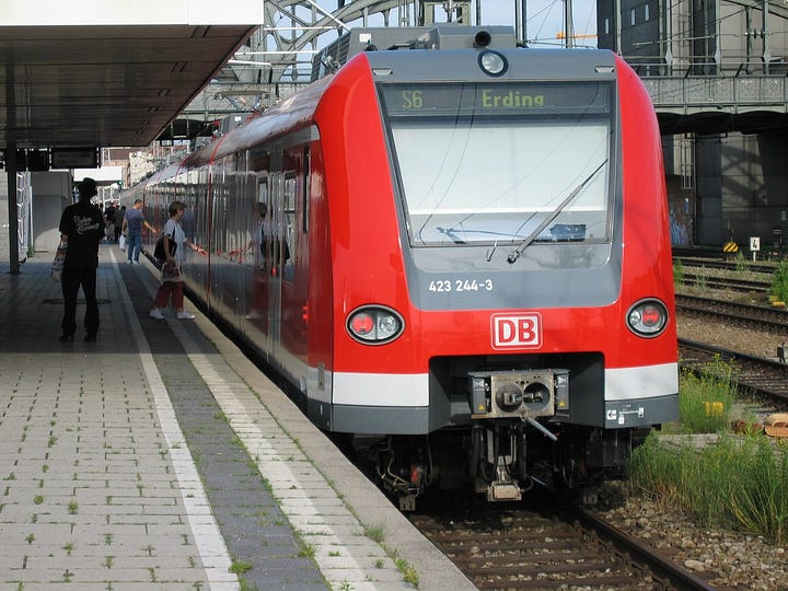
But city regions are normal even in places that have not implemented green belts. London’s twin sibling, Paris, is surrounded by outlying towns in the same way that London is: the only difference is that Paris has allowed its footprint to expand, so that there is a continuous belt of urbanisation. City regions are also found around smaller cities: towns like Erding (of beer fame) fall within Munich’s city region.
City regions are a natural feature of urbanisation: London is only unusual in the degree to which its city region is decentralised to towns like Reading. Nearly every city in the developed world has one.
Why a layered transport network?
The towns in a city region need a good rapid transit service to the city centre. At the same time, the urban area also needs rapid transit: to put the problem in a London context, people from both Hammersmith and Brighton need to be able to get into central London as easily as possible.
The fact that these two markets – the urban market and the city region market – have different needs can be illustrated by Munich’s railway network. The diagram below shows Munich’s city region, alongside the S-Bahn (in green) and its U-Bahn (other colours).

The existence of the S-Bahn and the U-Bahn is explained by a simple trade-off: stop spacing versus speed. The more often a train stops, the slower it will travel. Conversely, frequent stops mean more people are close to a station, which reduces their door-to-door journey times.
A circle of radius 10 km surrounding Munich’s central square, which is roughly the area served by the U-Bahn, has a population density1 of 5,140 people/km2 . Within this dense urban area, the U-Bahn stops roughly every 0.7–1.5 km, with each station having on average 26,200 people within a kilometre.
In other words, the U-Bahn sacrifices speed so that every station serves more people. This is the right way to make the trade-off, because the short distances travelled mean that journey times are never very long anyway: it only takes at most 24 minutes to get into the centre on the U-Bahn.
The model for the S-Bahn is quite different. The S-Bahn consists of pre-existing railway lines, which were upgraded into an rapid transit network by enabling them to run in a short tunnel through the centre of Munich and out the other side. The area it serves2 has a density of 368 people/km2.
The S-Bahn only stops where it really needs to: it has a station in every town, and also some in the urban area, although even there the stop spacing is wider than on the U-Bahn. It does not stop in minor villages. As a result, its average speed is much faster, so it can go further out while maintaining competitive travel times.
The differences between the two systems are shown clearly on the graph below, where the S-Bahn is in green, and the U-Bahn is in red.
One network, two systems
Each system is therefore designed to get the trade-off between speed and station spacing right for its segment of the market. But even though Munich has two separate systems, they are integrated into one network.
This is accomplished through interchange stations: the S-Bahn interchanges with every U-Bahn line in the city centre. Furthermore, shoulder stations, which enable people to change trains out in the suburbs rather than in the city centre, are used to knit the two systems together into one network.
Just as important as the infrastructure, Munich, like all German-speaking cities, has what is Teutonically known as a Verkehrsverbund, or transport alliance, which co-ordinates public transport across Munich’s city region.
The Verkehrsverbund does not own or operate any services itself: Munich’s S-Bahn is owned and operated by Deutsche Bahn, the national railway company, while the U-Bahn is owned and operated by the city. The Verkehrsverbund also includes busses and trams and regional train services, which are also owned and operated by different organisations.
Rather than operating anything itself, Munich’s Verkehrsverbund integrates fares into a zonal system, similar to London’s zonal system. (Unlike in London, the same pricing applies to buses and trams as well as trains.) This ensures passengers are not hit by any financial penalties when they are changing from one operator to another.
Getting layering right
Layering is a concept that is primarily used in Germany and neighbouring countries. Munich is the paradigmatic example, but I could have written similar things about any big German-speaking city.
Munich-style layering is also akin to the distinction between the Paris Métro and the RER, and also has parallels with the local/express services on the New York City Subway.
It is even similar to the division between inner and outer suburban services on the likes of Southwestern Railway.3 (These, incidentally, illustrate that London is big enough to have three layers: urban services operated by the Tube, DLR and Overground, inner suburban services like the Elizabeth Line branch out to Shenfield in Essex, and outer suburban services to places like Brighton.)
To be clear, layering does not mean a city’s urban area must be served by a metro system like the Munich U-Bahn. Layering is a different concept from the choice of which technology is best-suited to operating the layer.
For instance, the urban layer could use a tram as in Zurich, or by a tram-metro, which runs on the streets in the outskirts and in a tunnel in the centre, as in Cologne. This technological decision is determined by factors like capacity, travel time, costs and the feasibility of running trams on narrow streets.
In Britain, however, medium-sized cities don’t get layering right. Newcastle’s urban area, for instance, has the Tyne and Wear Metro. Although the Metro is not as extensive as it should be, for the places like Gateshead and North Shields that it does serve, it provides rapid transit of a quality that is rare in British cities outside of London.
What Newcastle is missing is an S-Bahn which would connect the city with towns like Peterlee, Hexham, Durham and Morpeth. These towns are outside the range of the Metro, but fall squarely into Newcastle’s city region. Currently, Peterlee and Hexham are served by unreliable, infrequent, diesel-operated trains, while Durham and Morpeth have to make do with long-distance services to and from London and the Midlands that are not set up for commuters.
British cities would do well to think about how to get layering right. It is not enough just to improve public transport within an urban area: Durham and Hexham are as interdependent on Newcastle as Gateshead and North Shields. Learning from the example of Munich’s layered network will allow all of these places to have a fast, frequent, reliable service into the city centre.
Figures from Population around a Point.
The S-Bahn serves a roughly 35 km radius from central Munich. This figure is the density of this area, but with the 10 km radius served by the U-Bahn removed. There are 1,602,000 within 10 km of the central square, the Marienplatz, and another 1,300,000 within the 35 km radius.
Inner suburban services run on the slow lines from Waterloo to places like Chessington or Hampton Court. Outer suburban services run on the fast lines within London’s urban area, and then go to places like Basingstoke or Farnham.


Great primer 👍